***

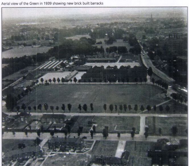
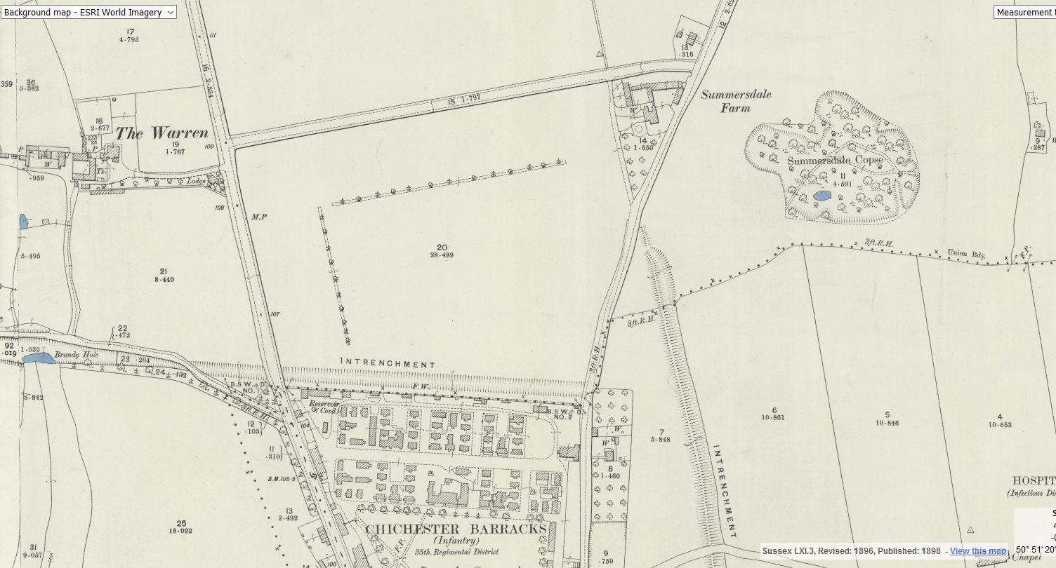
To the west of the Lavant Road, Warren Farm consisted of 67 acres
bounded to the north by Lavant Common, and to the south by Brandy Hole
Lane. The Ecclesiastical Commissioners, having taken the land over in
January 1870, sold it freehold a few months later to Robert Dendy, a local
banker, for £1,137.7s. He revitalised the farm and completed a period of re-
building by the early 1880s when the farm had to support six families.

The farm changed hands twice through widow Matilda Bagot in 1882 and
Charles Ormerod, who inherited when Matilda died in 1889, before Henry
Halsted bought it in 1894. Halsted was the owner of a local ironmongers,
and iron and brass foundry in South Pallant. He died in 1911 followed by his
wife Margaret in 1919.

The farm was auctioned in October 1919 but remained unsold. The 1920s
was still not a good time for farming, but Chichester was expanding and
there was demand for good quality housing. The property was divided into
individual but generous building plots along the Lavant Road, Brandy Hole
Lane, Warren Farm Lane, and what became known as Hunters Way. The
Warren, its drive, buildings, grounds and Warren Lodge were excluded, as
were fields on either side of the Chichester-Midhurst railway. The building
plots, all with the same Restrictive Covenants, were sold off in the 1920s
and 30s. (Stride’s plots on the other side of the Lavant Road, with similar
covenants, were sold a few years earlier).

***

In the 1860s, the Chichester to Midhurst railway was planned to cross under
Brandy Hole Lane and bisect Warren Farm on its way to Lavant, Midhurst
and Haslemere. It was to be a ‘contractors’ line, built by a group of
speculators for sale to an established railway company. The first sod was
turned by Lord Henry Lennox (MP for Chichester) in April 1865, but the
Haslemere section was officially abandoned in 1868. Financial and legal
wrangles continued to create severe delays and a second Parliamentary Bill

5

Random articles of interest

building a cellar

cellar image

Historically, to build a house with a simple cellar you would dig out the ground to a depth of around 6ft, the cellar walls would have been constructed with a lining of stone or brick and with a drain for water within the cellar. The floors would have been built up on crushed stone or sand to provide a level surface and paved, usually with flags. Brick paving became more common in later periods.

Read more: building a cellar

40 east street

EAST STREET No 40
SU 8604 NW 4/103
Grade II
C18. 3 storeys and attic. 2 windows. Red brick.

Panelled parapet hiding
dormers. Sash windows in reveals in flat arches; rubbed brick voussoirs; glazing bars missing in lower windows.

C20 plate glass shop front and fascia on ground floor.

Read more: 40 east street

Doline – Chichester To Westbourne

Doline  – Chichester To Westbourne

doline

 Brandy Hole Lane, East Broyle Copse area in the northwest part of Chichester. A well-developed doline line extends east-west across the area to the north of Brandy Hole Lane, along the underlying Chalk-Reading Beds boundary.


The Environment Agency has made 1m-resolution LIDAR imagery coverage for large areas of England and Wales freely available on the internet under Open Government Licence (www.lidarfinder.com).

Read more: Doline – Chichester To Westbourne

Russilon Barracks

The Chichester SMR holds information for 48 sites, whilst the National Monuments Record
Centre holds details of a further 16 sites within the study area. An additional four sites were
located through analysis of historic mapping and during the course of the walkover survey and
one from aerial photographs. Full site descriptions and locations can be seen in Appendix B.
Within the report, the bracketed numbers after site descriptions relate to those allocated to
individual sites in Appendix B and on Figure 2.

Read more: Russilon Barracks

summersdale golf course and mr Stride

Between The Drive’s western and southern ends, Charles Stride built a private estate in c.1905 which included a nine hole golf course designed by James Braid, a lodge (Uplands), and a mansion (Woodland Place) with tree-lined grounds which, as Rew Lane, was developed in the late 1950s. The golf course was too close to the Goodwood course to be a commercial success and it was given up for gravel extraction immediately prior to the first World War, with a mineral branch line connected later to the Chichester-Midhurst railway.
His golf course and pavilion is mentioned in https://golfsmissinglinks.co.uk/index.php/england/south-east/sussex/851-sus-summersdale-golf-club-chichester

The club was founded in 1904.

Read more: summersdale golf course and mr Stride

Architects concept plan - Graylingwell aerial designers dream

architects concept plan - graylingwell aerial designers dream. This vision is far from reality and some say even mention the trades description act.

Read more: Architects concept plan - Graylingwell aerial designers dream

Graylingwell plan with well and springs ponds

Graylingwell plan with well and springs ponds.

Read more: Graylingwell plan with well and springs ponds

Underneath Hansford Menswear

hansford menswear shop front

A number of those readers remembered a story about tunnels underneath Hansford Menswear, also in South Street, so we spoke the shop''s owner to find out more.
Matthew Hansford described a blocked-off passage in cellar of the shop, which he believes may have led to the cathedral

Read more: Underneath Hansford Menswear

tunnels underneath Hansford Menswear

A number of those readers remembered a story about tunnels underneath Hansford Menswear, also in South Street, so we spoke the shop's owner to find out more Matthew Hansford described a blocked-off passage in cellar of the shop, which he believes may have led to the cathedral

.

Read more: tunnels underneath Hansford Menswear

More In Articles