The Graylingwell Heritage Project has been a community based heritage and arts programme located in Chichester, West Sussex.
The original Victorian buildings had a central boiler house with the water tower which is, after the Cathedral spire, by far the tallest building in Chichester. And if you go up to the Trundle and look down on Chichester, the only two buildings you can see are the Cathedral spire and the Graylingwell water tower.
The base of the water tower was the central boiler house and there was a network, a sort of ring, of corridors linking all the wards. Below the corridors was a basement subway and all the heating pipework ran through that. The heating was done by steam, so the boilers generated steam, which was then circulated round through the subways. Each ward block had its own installation that heated hot water for radiators, so it was quite a forward-thinking system, but it was quite expensive to run because you have to be much more careful with steam. It’s much more dangerous if you had a leak than hot water, so it was quite an expensive system to maintain. - John Wilton
Random articles of interest
where are the tunnels?
Are you curious about the tunnels in Chichester? If you are, you are not alone. Many people have wondered about the existence and purpose of these underground passages that are said to run under the city. Some claim they have seen them, others have heard stories about them, but what is the truth behind the mystery?
In this blog post, I will try to shed some light on the tunnels in Chichester, based on some web searches and historical sources. I will also share some of the rumours and legends that surround them, and invite you to share your own experiences or opinions in the comments section.
MB My mum worked 27 east street and when it flooded in the 90s they found a big cellar and you could look down into an area which was like a tunnel
65 East Street
DD I worked at 65 East Street when it was ''Hammick''s Bookshop'' (now Specsavers). We had a trapdoor in the middle of the floor that led down to a tunnel-shaped cellar that seemed to extend through the front of the shop and under the pavement outside. I didn''t see any evidence of it ever having joined another tunnel and imagine that perhaps there was once an opening in the pavement for deliveries.
\r\n
peterborough tunnels
One of the most common questions I’m asked about Peterborough’s history is whether there are any tunnels under the city. Local legends say that there is a tunnel stretching from the Cathedral to Monk’s Cave at Longthorpe. Similar tunnels are alleged to stretch from the Cathedral to the abbeys at Thorney or Crowland.
These are familiar myths in many historic cities across the UK, mostly urban legends based on half remembrances of sewers, cellars or crawlspaces, coupled with wishful thinking and rumour.
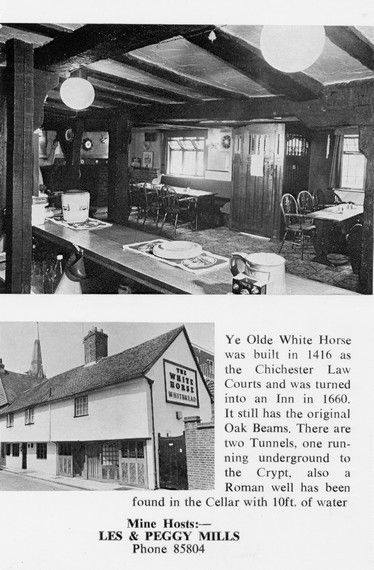
Max T I recall that there is a short length of tunnel (blocked off at both ends) under the old White Horse pub in South St. (now Prezzo restaurant, since 2005). Story in the pub was that it was part of a tunnel running from the Cathedral up to the Guildhall in Priory Park. Although the tunnel is there, I was never sure of its true purpose or the truth of its start / finish. Thought that it was worth mentioning it on here though.
The Chichester SMR holds information for 48 sites, whilst the National Monuments Record Centre holds details of a further 16 sites within the study area. An additional four sites were located through analysis of historic mapping and during the course of the walkover survey and one from aerial photographs. Full site descriptions and locations can be seen in Appendix B. Within the report, the bracketed numbers after site descriptions relate to those allocated to individual sites in Appendix B and on Figure 2.
AArc141/14/EVAL Roussillon Park, Broyle Road, Chichester, West Sussex, PO19 BBL
Sporadic finds represent the early prehistoric period in the vicinity of the Project Site, with the discovery of Palaeolithic axe in a garden on Brandy Hole Lane (c. 600m to the NW) and a Neolithic stone axe, in the vicinity of Spitalfield Lane, over 1km to the SE (Lee 2008: 9).
Bronze Age activity has been recorded c. 500m to the east of the site, in the vicinity of Garyiingwell Hospital, where evidence for settlement was identified along with remains of six cremation burials (Lee 2008: 9).
It was under the Crypt and right next to the cathedral
Maureen Williams, 82, of Westgate, recalled a school trip into the rumoured tunnels under Chichester when she was at Chichester High School for Girls.
She estimates she was in her early teens at the time and said she chose to share her memories after reading about the search for evidence in this newspaper.


