Summersdale Neighbourhood Character Appraisal
Introduction

Several villages around Chichester have written Village Design Statements
(VDS) and had them accepted by the Executive of Chichester District
Council (CDC) as material considerations in the determination of planning
applications. The Summersdale Residents Association (SRA) believed a
similar such document would provide a measure of enlightened protection
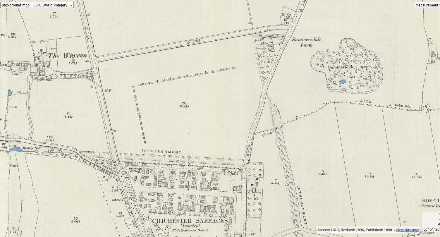
against inappropriate development in its historic suburb. Detailed research
into the area’s housing stock and its settlement pattern provided the base
data.

Several examples of local VDS were studied and typical contents defined
before it became apparent that they were invariably written in conjunction
with the appropriate Parish Council, the first legitimate layer of local
government, thereby conferring status on the documents. Summersdale is
not a village but a neighbourhood or suburb, so the SRA document came
to be known as a Neighbourhood Appraisal. To enhance its prospects of
acceptance by the Executive, the CDC advised the SRA to develop it in
conjunction with its own Parish Council — namely the Chichester City
Council. The SRA’s subsequent membership of the NE Chichester City
Forum would facilitate closer links with the statutory bodies represented
thereon.

Links with the City Council were established in late 2007 and agreement
reached that the City Council’s Planning & Conservation Committee (P&C)
would assume co-ownership of the document so as to use it as a
template for other groups within the City, each document supporting the
City Council’s next Town Plan. The SRA’s base data was shared with the
P&C Committee, and development of the collaborative document began in
early 2008. The format for the document was devised by a sub-group of
the P&C Committee, and the title changed to Summersdale
Neighbourhood Character Appraisal, in line with the Chichester District
Council’s document — the Chichester Conservation Area Character
Appraisal. The size of the document was prescribed, as was the need for
some form of community involvement.

After adoption by the City Council, the joint Appraisal will be published
and comments invited via newsletters, notice boards, and the web sites of
both the City Council and the SRA. All comments will be welcomed and
reflected in the document to be submitted to the District Council for
approval and wider circulation.

Random articles of interest

White Horse / Prezzo

whitehorse

Max T
I recall that there is a short length of tunnel (blocked off at both ends) under the old White Horse pub in South St. (now Prezzo restaurant, since 2005). Story in the pub was that it was part of a tunnel running from the Cathedral up to the Guildhall in Priory Park. Although the tunnel is there, I was never sure of its true purpose or the truth of its start / finish. Thought that it was worth mentioning it on here though.


Read more: White Horse / Prezzo

Old Barracks / Wellington Grange

Old Barracks / Wellington Grange

Read more: Old Barracks / Wellington Grange

tunnels underneath Hansford Menswear

A number of those readers remembered a story about tunnels underneath Hansford Menswear, also in South Street, so we spoke the shop's owner to find out more Matthew Hansford described a blocked-off passage in cellar of the shop, which he believes may have led to the cathedral

.

Read more: tunnels underneath Hansford Menswear

summersdale golf course and mr Stride

Between The Drive’s western and southern ends, Charles Stride built a private estate in c.1905 which included a nine hole golf course designed by James Braid, a lodge (Uplands), and a mansion (Woodland Place) with tree-lined grounds which, as Rew Lane, was developed in the late 1950s. The golf course was too close to the Goodwood course to be a commercial success and it was given up for gravel extraction immediately prior to the first World War, with a mineral branch line connected later to the Chichester-Midhurst railway.
His golf course and pavilion is mentioned in https://golfsmissinglinks.co.uk/index.php/england/south-east/sussex/851-sus-summersdale-golf-club-chichester

The club was founded in 1904.

Read more: summersdale golf course and mr Stride

Chichester Culverts

We do not suggest going into the culverts.
These are not classified as tunnels and can be dangerous

 video of culverts/storm drains/winterbourne route


Map of Chichester showing Rivers


www.streetmap.co.uk\\/map.srf?x=486359&y=104953&z=120&sv=chichester&st=3&tl=Map%20of%20Chichester%2C%20West%20Sussex%20[City%2FLarge%20Town]&searchp=ids.srf&mapp=map.srf&fbclid=IwAR2IV7YUeQ8u_GBTHRE24fSpUvVRwu5CpZxdPt1fs_injtw73WMxXbTQ25s

Russilon Barracks

The Chichester SMR holds information for 48 sites, whilst the National Monuments Record
Centre holds details of a further 16 sites within the study area. An additional four sites were
located through analysis of historic mapping and during the course of the walkover survey and
one from aerial photographs. Full site descriptions and locations can be seen in Appendix B.
Within the report, the bracketed numbers after site descriptions relate to those allocated to
individual sites in Appendix B and on Figure 2.

Read more: Russilon Barracks

building a cellar

cellar image

Historically, to build a house with a simple cellar you would dig out the ground to a depth of around 6ft, the cellar walls would have been constructed with a lining of stone or brick and with a drain for water within the cellar. The floors would have been built up on crushed stone or sand to provide a level surface and paved, usually with flags. Brick paving became more common in later periods.

Read more: building a cellar

Doline – Chichester To Westbourne

Doline  – Chichester To Westbourne

doline

 Brandy Hole Lane, East Broyle Copse area in the northwest part of Chichester. A well-developed doline line extends east-west across the area to the north of Brandy Hole Lane, along the underlying Chalk-Reading Beds boundary.


The Environment Agency has made 1m-resolution LIDAR imagery coverage for large areas of England and Wales freely available on the internet under Open Government Licence (www.lidarfinder.com).

Read more: Doline – Chichester To Westbourne

whyke lodge


More In Articles